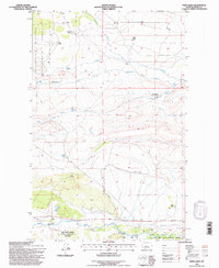
1995 Map of Twin Lakes
USGS Topo · Published 1997About this map
Pine Butte Swamp Nature Conservancy Preserve anchors the southern landscape of this 1995 revision, where the Teton River flows through a complex network of seasonal drainages and foothills. The terrain is defined by the transition from the high plains into the mountain front, marked by the Blackleaf Wildlife Management Area in the northwest. Local history is traced through a scattered system of ranch holdings, including the Knowlton Ranch, Pollock Ranch, and the Clark Brothers Ranch (Aband). Water distribution is the primary driver of the area's development, with Muddy Creek and its various forks, such as the Clark Fork Muddy Creek, carving paths across the quadrangle. The presence of Twin Lakes and a Gaging Sta on the Teton reflects the critical importance of water management in this Teton County landscape during the late twentieth century.
Find a feature on this map
17 named features on this map. Tap any name to fly to it.
Don’t see what you’re looking for? This feature index may not catch every label — zoom into the map to look around manually.
Map Details
Editions of this 1995 Twin Lakes Map
This is the sole edition of this map. No revisions or reprints were ever made.
Other maps of this area

1903 · Saypo
USGS Topo · 1:125,000

1914 · Heart Butte
USGS Topo · 1:125,000

1918 · Heart Butte
USGS Topo · 1:125,000

1920 · Choteau
USGS Topo · 1:125,000

1920 · Dupuyer
USGS Topo · 1:125,000

1936 · Pendroy
USGS Topo · 1:48,000

1941 · Pendroy
USGS Topo · 1:62,500

1955 · Choteau
USGS Topo · 1:250,000

1957 · Choteau
USGS Topo · 1:250,000

1958 · Choteau
USGS Topo · 1:250,000