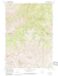
1969 Map of Twin Peaks
USGS Topo · Published 1985About this map
Shoshone National Forest defines this high-altitude landscape where the headwaters of the Wood River system converge. Surveyed in the late 1960s, the terrain is marked by a network of drainage basins including the Middle Fork, South Fork, and East Fork Wood River, all deeply incised between peaks like Standard Peak and Dome Mountain. The convergence of administrative boundaries is a central theme of this sheet, as the Park and Hot Springs county line and the Wind River Indian Reservation boundary cross these remote valleys. Human presence is indicated primarily by back-country infrastructure, including a series of Pack Trails that connect Guard Station Park and Mc Gregor Park across the high divides near Twin Peaks.
Find a feature on this map
28 named features on this map. Tap any name to fly to it.
Don’t see what you’re looking for? This feature index may not catch every label — zoom into the map to look around manually.
Map Details
Editions of this 1969 Twin Peaks Map
2 editions found
Other maps of this area

1904 · Kirwin
USGS Topo · 1:125,000

1906 · Kirwin
USGS Topo · 1:125,000

1955 · Thermopolis
USGS Topo · 1:250,000

1958 · Thermopolis
USGS Topo · 1:250,000

1962 · Thermopolis
USGS Topo · 1:250,000

1967 · Willow Creek
USGS Topo · 1:24,000

1967 · Monument Peak
USGS Topo · 1:24,000
1967 · East Fork Basin
USGS Topo · 1:24,000
1969 · Cottonwood Peak
USGS Topo · 1:24,000
1969 · Twin Peaks
USGS Topo · 1:24,000