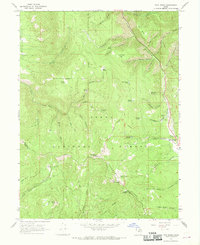
1967 Map of Twin Peaks
USGS Topo · Published 1969About this map
The high ridge lines of the Uinta National Forest dominate this landscape during the late 1960s, defined by the towering summits of Strawberry Peak and Twin Peaks. The complex drainage system of the Wasatch Range is meticulously documented here, with the North Fork and East Fork feeding into Daniels Creek alongside the main route of U.S. 40. One of the most significant historical markers on the sheet is the Old Indian Treaty Boundary, which cuts across the high country between Barrys Reservoir and Strawberry Peak. The map reveals a remote terrain accessible primarily by jeep trails and horse paths, winding through family-named landmarks like Wadsworth Peak and Soldier Bench. Localized water sources such as Circle Spring and Burnt Stump Spring provided critical stopping points for those navigating the high-altitude benches and glades including Big Glade and Dockweed Flat.
Find a feature on this map
42 named features on this map. Tap any name to fly to it.
Don’t see what you’re looking for? This feature index may not catch every label — zoom into the map to look around manually.
Map Details
Editions of this 1967 Twin Peaks Map
2 editions found
Other maps of this area

1885 · Salt Lake
USGS Topo · 1:250,000

1907 · Strawberry Valley
USGS Topo · 1:125,000

1909 · Strawberry Valley
USGS Topo · 1:125,000

1954 · Salt Lake City
USGS Topo · 1:250,000

1958 · Salt Lake City
USGS Topo · 1:250,000

1960 · Salt Lake City
USGS Topo · 1:250,000

1966 · Strawberry Reservoir NW
USGS Topo · 1:24,000
1966 · Charleston
USGS Topo · 1:24,000

1967 · Two Tom Hill
USGS Topo · 1:24,000
1967 · Granger Mtn
USGS Topo · 1:24,000