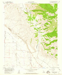
1959 Map of Twitchell Dam
USGS Topo · Published 1960About this map
Twitchell Dam and its newly formed Twitchell Reservoir anchor this 1959 study of the rugged interface between San Luis Obispo and Santa Barbara counties. The map documents a critical hydrological junction where the Cuyama River and Sisquoc River converge to form the Santa Maria River. This area is defined by the transition from the steep San Rafael Mountains down into the Santa Maria Valley, a landscape managed by a complex network of engineering features including a Spillway Tunnel, Gaging Stations, and extensive Levees. Rural settlements like Garey, Gates, and Rex appear alongside the expansive Santa Maria Grant boundary, illustrating the persistence of older land divisions. The presence of numerous Oil Wells in the southern canyonlands highlights the region's mid-century petroleum industry amidst family-named landmarks like Fulger Point and Cañada de los Coches.
Find a feature on this map
30 named features on this map. Tap any name to fly to it.
Don’t see what you’re looking for? This feature index may not catch every label — zoom into the map to look around manually.
Map Details
Editions of this 1959 Twitchell Dam Map
3 editions found
Other maps of this area

1905 · Lompoc
USGS Topo · 1:125,000

1922 · Nipomo
USGS Topo · 1:62,500

1937 · Branch Mtn
USGS Topo · 1:48,000

1942 · Lompoc
USGS Topo · 1:125,000

1942 · Santa Maria
USGS Topo · 1:62,500

1942 · Branch Mountain
USGS Topo · 1:62,500

1942 · Tepusquet Peak
USGS Topo · 1:62,500

1943 · Tepusquet Peak
USGS Topo · 1:62,500

1943 · Lompoc
USGS Topo · 1:125,000

1947 · Careaga Canyon
USGS Topo · 1:24,000