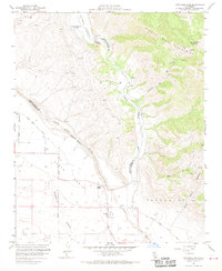
1959 Map of Twitchell Dam
USGS Topo · Published 1970About this map
The Twitchell Dam and its resulting Twitchell Reservoir dominate this 1959 survey of the rugged California coastal range. Located at the confluence where the Cuyama River meets the Santa Maria River, the dam represents a significant mid-century hydrological project by the Bureau of Reclamation. The map captures the complex terrain of the Sierra Madre Mountains to the east, including Las Coches Mtn and the steep drainages of Coches Canyon.
Find a feature on this map
1 named feature on this map. Tap any name to fly to it.
Don’t see what you’re looking for? This feature index may not catch every label — zoom into the map to look around manually.
Map Details
Editions of this 1959 Twitchell Dam Map
3 editions found
Other maps of this area

1905 · Lompoc
USGS Topo · 1:125,000

1922 · Nipomo
USGS Topo · 1:62,500

1937 · Branch Mtn
USGS Topo · 1:48,000

1942 · Lompoc
USGS Topo · 1:125,000

1942 · Santa Maria
USGS Topo · 1:62,500

1942 · Branch Mountain
USGS Topo · 1:62,500

1942 · Tepusquet Peak
USGS Topo · 1:62,500

1943 · Tepusquet Peak
USGS Topo · 1:62,500

1943 · Lompoc
USGS Topo · 1:125,000

1947 · Careaga Canyon
USGS Topo · 1:24,000