
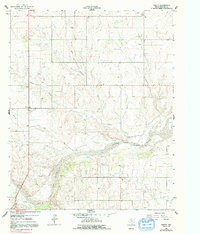
1962 Map of Twitty
USGS Topo · Published 1965About this map
The North Fork Red River carves a winding path across the southern portion of this Panhandle landscape, defining the topography of Wheeler County in the early 1960s. The small settlement of Twitty sits near the center of the sheet, serving as a local hub amidst a network of drainage systems like Bronco Creek and its East Branch. The map reveals the industrial footprint of the era, specifically within the expansive Gas Field that occupies the river's northern banks. This energy production infrastructure, including scattered Oil Wells, is balanced by localized features like the Center Cem and a nearby Sandpit. The terrain is also marked by several seasonal water sources, simply labeled Spring, which were vital for the ranching operations that historically dominated this part of the Texas plains.
Find a feature on this map
11 named features on this map. Tap any name to fly to it.
Don’t see what you’re looking for? This feature index may not catch every label — zoom into the map to look around manually.
Map Details
Editions of this 1962 Twitty Map
2 editions found
Other maps of this area

1954 · Amarillo
USGS Topo · 1:250,000

1958 · Amarillo
USGS Topo · 1:250,000

1962 · Kelton SE
USGS Topo · 1:24,000

1962 · Wheeler
USGS Topo · 1:24,000

1962 · Wheeler SE
USGS Topo · 1:24,000

1963 · Kelton
USGS Topo · 1:24,000

1963 · Kelton NW
USGS Topo · 1:24,000

1963 · Fulller
USGS Topo · 1:24,000

1963 · Shamrock East
USGS Topo · 1:24,000

1963 · Shamrock West
USGS Topo · 1:24,000