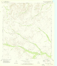
1973 Map of Two Mill Draw East
USGS Topo · Published 1976About this map
Monument Draw and Maverick Draw carve through the arid high country of Culberson County in this mid-1970s survey. The landscape is defined by its drainage systems, where ephemeral flows like Two Mill Draw and Big Canyon Draw converge toward Cottonwood Creek in the southeast. Human presence is sparse and tied directly to water and resource extraction, marked by the Brooks Ranch and the vital Humphrey Windmill near a natural Spring.
Find a feature on this map
13 named features on this map. Tap any name to fly to it.
Don’t see what you’re looking for? This feature index may not catch every label — zoom into the map to look around manually.
Map Details
Editions of this 1973 Two Mill Draw East Map
This is the sole edition of this map. No revisions or reprints were ever made.
Other maps of this area

1928 · Kent
USGS Topo · 1:125,000

1954 · Van Horn
USGS Topo · 1:250,000

1958 · Van Horn
USGS Topo · 1:250,000

1973 · Dellahunt Draw West
USGS Topo · 1:24,000

1973 · Two Mill Draw West
USGS Topo · 1:24,000

1973 · Seven L Peak NE
USGS Topo · 1:24,000

1973 · Rustler Hills
USGS Topo · 1:24,000
1973 · Dellahunt Draw East
USGS Topo · 1:24,000
1973 · Dry Lake
USGS Topo · 1:24,000
1973 · Derrick Draw
USGS Topo · 1:24,000