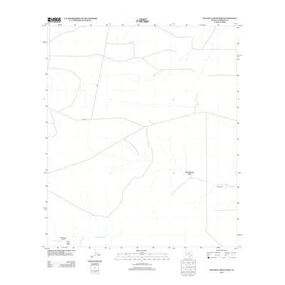
2012 Map of Two Mill Draw West
USGS Topo · Published 2012About this map
Old Christian Place sits within a high-desert landscape in Culberson County, where the topography is defined by seasonal watercourses and remote ranching infrastructure. Arid drainages such as Budweiser Draw, Paint Horse Draw, and Cottonwood Cr carve through the terrain, illustrating the importance of water management in this part of West Texas. The presence of the West Windmill further emphasizes the reliance on groundwater for sustaining the scattered homesteads and livestock operations in this territory. Transportation is limited to a sparse network of rural routes, including 7 L Rd and Nevel Rd, which connect the isolated sites across the vast flats. This 2012 survey by the U.S. Geological Survey documents the enduring character of the Trans-Pecos ranching frontier, where named landmarks often represent single family-held properties or critical water sources.
Find a feature on this map
7 named features on this map. Tap any name to fly to it.
Don’t see what you’re looking for? This feature index may not catch every label — zoom into the map to look around manually.
Map Details
Editions of this 2012 Two Mill Draw West Map
This is the sole edition of this map. No revisions or reprints were ever made.
Other maps of this area

1928 · Kent
USGS Topo · 1:125,000

1954 · Van Horn
USGS Topo · 1:250,000

1958 · Van Horn
USGS Topo · 1:250,000

1973 · Dellahunt Draw West
USGS Topo · 1:24,000

1973 · Seven L Peak
USGS Topo · 1:24,000

1973 · Two Mill Draw West
USGS Topo · 1:24,000

1973 · Seven L Peak NE
USGS Topo · 1:24,000

1973 · Rustler Hills
USGS Topo · 1:24,000

1973 · K C Ranch
USGS Topo · 1:24,000
1973 · Dellahunt Draw East
USGS Topo · 1:24,000