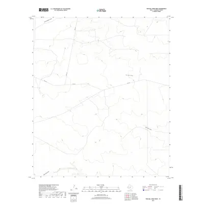
2019 Map of Two Mill Draw West
USGS Topo · Published 2019About this map
Two Mill Draw and Big Canyon Draw carve through the high desert landscape of Culberson County, defining the drainage patterns of this sparsely populated ranching region. The 2019 survey illustrates a terrain dominated by ephemeral watercourses and remote ranch roads, where elevation changes are marked by the winding paths of Running Water Draw and Paint Horse Draw. Human presence is minimal, etched into the map primarily through established thoroughfares like Seven L Rd and Nevel Rd, which provide the only consistent access across the undulating contours. To the south, the presence of Cottonwood Cr suggests an area where local hydrology occasionally supports different vegetation. This map serves as a precise record of the physical geography and existing infrastructure in a secluded corner of West Texas, capturing the intersection of natural drainage and modern rural access.
Find a feature on this map
7 named features on this map. Tap any name to fly to it.
Don’t see what you’re looking for? This feature index may not catch every label — zoom into the map to look around manually.
Map Details
Editions of this 2019 Two Mill Draw West Map
This is the sole edition of this map. No revisions or reprints were ever made.
Other maps of this area

1928 · Kent
USGS Topo · 1:125,000

1954 · Van Horn
USGS Topo · 1:250,000

1958 · Van Horn
USGS Topo · 1:250,000

1973 · Dellahunt Draw West
USGS Topo · 1:24,000

1973 · Seven L Peak
USGS Topo · 1:24,000

1973 · Two Mill Draw West
USGS Topo · 1:24,000

1973 · Seven L Peak NE
USGS Topo · 1:24,000

1973 · Rustler Hills
USGS Topo · 1:24,000

1973 · K C Ranch
USGS Topo · 1:24,000
1973 · Dellahunt Draw East
USGS Topo · 1:24,000