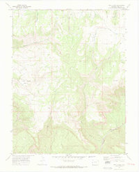
1969 Map of Two V Basin
USGS Topo · Published 1973About this map
Two V Ranch sits near the head of the deeply incised Two V Basin in this 1969 topographic study of Mesa County. The landscape is defined by a series of parallel drainages, including Middle Canyon and Briar Canyon, that feed into larger systems like Granite Creek. This era of the late 1960s highlights the limited but vital infrastructure of the high plateau, notably the M S Road and a remote Radio Facility located on a high point near the eastern margin.
Find a feature on this map
22 named features on this map. Tap any name to fly to it.
Don’t see what you’re looking for? This feature index may not catch every label — zoom into the map to look around manually.
Map Details
Editions of this 1969 Two V Basin Map
3 editions found
Other maps of this area

1885 · La Sal
USGS Topo · 1:250,000

1949 · Gateway
USGS Topo · 1:24,000

1950 · Pine Mountain
USGS Topo · 1:24,000

1952 · Gateway
USGS Topo · 1:24,000

1954 · Mt. Waas 4 NE
USGS Topo · 1:24,000

1954 · Mt. Waas 1 NE
USGS Topo · 1:24,000

1954 · Mt. Waas 1 SE
USGS Topo · 1:24,000

1954 · Coates Creek
USGS Topo · 1:62,500

1954 · Polar Mesa
USGS Topo · 1:62,500

1956 · Moab
USGS Topo · 1:250,000