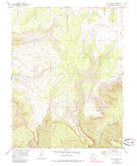
1969 Map of Two V Basin
USGS Topo · Published 1985About this map
Two V Basin and the adjacent Lost Horse Basin characterize this section of Mesa County, where the topography transitions through deep drainages toward the Unaweep Canyon (West Fork). Published in the mid-1980s from late-1960s photogrammetric data, the map reveals a remote landscape of canyons and creeks punctuated by isolated ranching and infrastructure sites. Evidence of high-country land use is visible at the Two V Ranch, while the presence of a Radio Facility and the small settlement of King indicate modern additions to an area dominated by natural features like Granite Creek and McKenzie Canyon. The network of seasonal watercourses, including Bieser Creek and Bull Draw, illustrates the complex erosion patterns that define the canyon country of western Colorado.
Find a feature on this map
19 named features on this map. Tap any name to fly to it.
Don’t see what you’re looking for? This feature index may not catch every label — zoom into the map to look around manually.
Map Details
Editions of this 1969 Two V Basin Map
3 editions found
Other maps of this area

1885 · La Sal
USGS Topo · 1:250,000

1949 · Gateway
USGS Topo · 1:24,000

1950 · Pine Mountain
USGS Topo · 1:24,000

1952 · Gateway
USGS Topo · 1:24,000

1954 · Mt. Waas 4 NE
USGS Topo · 1:24,000

1954 · Mt. Waas 1 NE
USGS Topo · 1:24,000

1954 · Mt. Waas 1 SE
USGS Topo · 1:24,000

1954 · Coates Creek
USGS Topo · 1:62,500

1954 · Polar Mesa
USGS Topo · 1:62,500

1956 · Moab
USGS Topo · 1:250,000