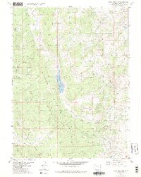
1980 Map of Tyler Mountain
USGS Topo · Published 1986About this map
The boundary between the Routt National Forest and Arapaho National Forest bisects this high-country landscape, where the waters of the Gore Pass region flow through a complex network of canyons and peaks. At the center of the drainage system lies the Red Dirt Reservoir (Mc Mahon Res No 2), capturing flow from Red Dirt Creek as it descends through the forest. This 1980 survey emphasizes the transition from the high summit of Tyler Mountain down toward the winding drainages of Buffalo Creek and Draper Creek.
Find a feature on this map
24 named features on this map. Tap any name to fly to it.
Don’t see what you’re looking for? This feature index may not catch every label — zoom into the map to look around manually.
Map Details
Editions of this 1980 Tyler Mountain Map
3 editions found
Other maps of this area

1954 · Craig
USGS Topo · 1:250,000

1956 · Lake Agnes
USGS Topo · 1:24,000

1956 · Kremmling
USGS Topo · 1:62,500

1956 · Whiteley Peak
USGS Topo · 1:24,000

1956 · Walton Peak
USGS Topo · 1:24,000

1956 · Gore Pass
USGS Topo · 1:62,500

1956 · Hyannis Peak
USGS Topo · 1:62,500

1956 · Rabbit Ears Peak
USGS Topo · 1:62,500

1957 · Craig
USGS Topo · 1:250,000

1958 · Craig
USGS Topo · 1:250,000