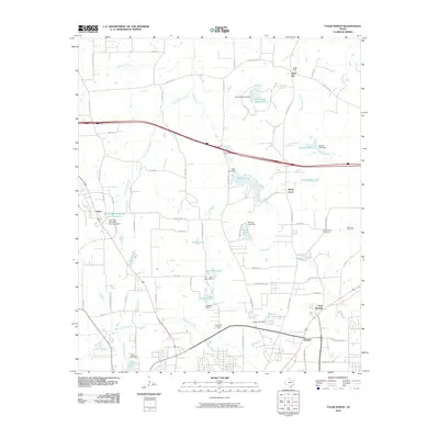
2010 Map of Tyler North
USGS Topo · Published 2010About this map
Tyler State Park Lake and the surrounding pine-filled hills of Smith County define the landscape of this 2010 survey. The area north of Tyler is characterized by a dense network of water resources and small, established communities. Named settlements such as Sand Flat, Swan, and Pine Springs are connected by a web of rural roads, including Old Tyler Hwy and State Park Hwy. The map reveals a complex hydrology of small lakes and dams, such as Hitts Lake, Federal Lake, and Tyler Pipe Industries Lake Number 2, illustrating the localized management of the Black Fork Creek and Little Saline Creek watersheds.
Find a feature on this map
81 named features on this map. Tap any name to fly to it.
Don’t see what you’re looking for? This feature index may not catch every label — zoom into the map to look around manually.
Map Details
Editions of this 2010 Tyler North Map
This is the sole edition of this map. No revisions or reprints were ever made.
Other maps of this area

1938 · Winona
USGS Topo · 1:48,000

1943 · Winona
USGS Topo · 1:62,500

1948 · Tyler
USGS Topo · 1:62,500

1949 · Tyler
USGS Topo · 1:62,500

1956 · Tyler
USGS Topo · 1:250,000

1960 · Hawkins
USGS Topo · 1:24,000

1960 · Lindale
USGS Topo · 1:24,000

1960 · Crow
USGS Topo · 1:24,000

1966 · Chandler
USGS Topo · 1:24,000
1966 · Tyler North
USGS Topo · 1:24,000