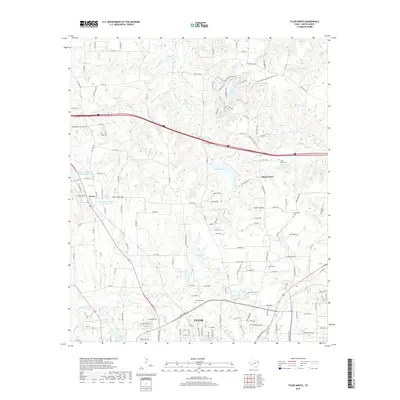
2019 Map of Tyler North
USGS Topo · Published 2019About this map
Tyler and its northern outskirts in Smith County are characterized by a dense network of small lakes and creek drainages that historically shaped the region's development. Water features like Hitts Lake, Spring Lake, and the larger Tyler State Park Lake define the northern landscape, while Black Fork Cr and its tributaries wind through the terrain. The map captures the interface between the urban growth of Montgomery Gardens and the long-established rural communities of Swan and Shady Grove. Genealogists will find significant value in the preservation of several local burial grounds, including the large Evergreen Cem and smaller sites like Shamburber Cem and Old Butler Cem. The presence of Beauchamps Springs and Cousin Spring highlights the area's natural hydrology, which supported these settlements before modern municipal expansion.
Find a feature on this map
152 named features on this map. Tap any name to fly to it.
Don’t see what you’re looking for? This feature index may not catch every label — zoom into the map to look around manually.
Map Details
Editions of this 2019 Tyler North Map
This is the sole edition of this map. No revisions or reprints were ever made.
Other maps of this area

1938 · Winona
USGS Topo · 1:48,000

1943 · Winona
USGS Topo · 1:62,500

1948 · Tyler
USGS Topo · 1:62,500

1949 · Tyler
USGS Topo · 1:62,500

1956 · Tyler
USGS Topo · 1:250,000

1960 · Hawkins
USGS Topo · 1:24,000

1960 · Lindale
USGS Topo · 1:24,000

1960 · Crow
USGS Topo · 1:24,000

1966 · Chandler
USGS Topo · 1:24,000
1966 · Tyler North
USGS Topo · 1:24,000