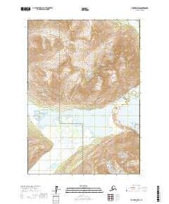
2017 Map of Tyonek A-8 NW
USGS Topo · Published 2017About this map
Lake Clark National Park forms the heart of this landscape, where high-altitude glacial runoff feeds into a network of significant waterways. The centerpiece is Kenibuna Lake, a large body of water that acts as a hydrologic hub for the surrounding peaks. This area is defined by the massive Shamrock Glacier to the east, which feeds the small Shamrock Lake and contributes to the flow of the Chukachatna River. The map illustrates a complex drainage system where the Chilligan River flows from the north and the Ivitna River and Neacola River carve through the southern reaches of the quadrangle. The lack of roads or permanent structures underscores the wilderness character of the Kenai Peninsula in the early 21st century, revealing a terrain shaped almost entirely by ice and moving water.
Find a feature on this map
12 named features on this map. Tap any name to fly to it.
Don’t see what you’re looking for? This feature index may not catch every label — zoom into the map to look around manually.
Map Details
Editions of this 2017 Tyonek A-8 NW Map
This is the sole edition of this map. No revisions or reprints were ever made.
Other maps of this area

1949 · Tyonek
USGS Topo · 1:250,000

1951 · Tyonek
USGS Topo · 1:250,000

1951 · Lime Hills
USGS Topo · 1:250,000

1958 · Tyonek B-8
USGS Topo · 1:63,360

1958 · Tyonek
USGS Topo · 1:250,000

1958 · Tyonek A-8
USGS Topo · 1:63,360

1958 · Lime Hills B-1
USGS Topo · 1:63,360
1958 · Lime Hills A-1
USGS Topo · 1:63,360

1958 · Lime Hills
USGS Topo · 1:250,000

1965 · Tyonek
USGS Topo · 1:250,000