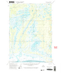
1958 Map of Tyonek B-1
USGS Topo · Published 1965About this map
The Little Susitna River winds through a complex wetland landscape in the late 1950s, characterized by the expansive Susitna Flats and the nearby Knik Arm. This survey illustrates a remote region where development is limited to isolated survival and aviation infrastructure, including a Landing Area with radio tower tanks and scattered Cabins. The terrain is dominated by a dense network of water bodies such as Horseshoe Lake, Twin Island Lake, and Yohn Lake, which are interconnected by drainages like Fish Creek and Maguire Creek. Surface transportation is represented by a solitary Tractor Trail cutting through the northern and eastern reaches, reflecting the era's reliance on specialized vehicles and aircraft to navigate the marshy ground and tidal Mud flats.
Find a feature on this map
18 named features on this map. Tap any name to fly to it.
Don’t see what you’re looking for? This feature index may not catch every label — zoom into the map to look around manually.
Map Details
Editions of this 1958 Tyonek B-1 Map
4 editions found

Other maps of this area

1949 · Tyonek
USGS Topo · 1:250,000

1950 · Anchorage C-8
USGS Topo · 1:63,360

1951 · Anchorage
USGS Topo · 1:250,000

1951 · Tyonek
USGS Topo · 1:250,000

1951 · Tyonek A-2
USGS Topo · 1:63,360

1951 · Tyonek A-1
USGS Topo · 1:63,360

1952 · Anchorage C-8
USGS Topo · 1:63,360

1952 · Tyonek C-1
USGS Topo · 1:63,360

1952 · Tyonek A-2
USGS Topo · 1:63,360

1952 · Tyonek A-1
USGS Topo · 1:63,360