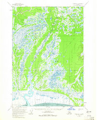
1958 Map of Tyonek B-1
USGS Topo · Published 1965About this map
The Little Susitna River meanders across this coastal Alaskan landscape as it approached its eventual outlet into the Knik Arm. Based on 1951 aerial photography with 1958 field annotations, this survey illustrates a largely unpopulated wilderness defined by complex hydrology. The southern reaches are dominated by the Susitna Flats, a tidally influenced transition zone where the river system meets the mudflats. Evidence of human presence is minimal, localized to a single Landing Area and scattered Cabin or Cabins labels, suggesting a landscape used primarily for seasonal hunting, fishing, or trapping. A network of Tractor Trails provides the only overland connectivity between the dozens of scattered water bodies like Twin Island Lake, Horseshoe Lake, and Yohn Lake, which punctuate the low-lying terrain.
Find a feature on this map
16 named features on this map. Tap any name to fly to it.
Don’t see what you’re looking for? This feature index may not catch every label — zoom into the map to look around manually.
Map Details
Editions of this 1958 Tyonek B-1 Map
4 editions found

Other maps of this area

1949 · Tyonek
USGS Topo · 1:250,000

1950 · Anchorage C-8
USGS Topo · 1:63,360

1951 · Anchorage
USGS Topo · 1:250,000

1951 · Tyonek
USGS Topo · 1:250,000

1951 · Tyonek A-2
USGS Topo · 1:63,360

1951 · Tyonek A-1
USGS Topo · 1:63,360

1952 · Anchorage C-8
USGS Topo · 1:63,360

1952 · Tyonek C-1
USGS Topo · 1:63,360

1952 · Tyonek A-2
USGS Topo · 1:63,360

1952 · Tyonek A-1
USGS Topo · 1:63,360