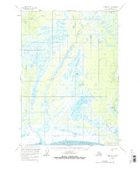
1958 Map of Tyonek B-1
USGS Topo · Published 1965About this map
Little Susitna River meanders through a vast expanse of wetlands and muskeg as it approaches the coast in this 1950s-era topographical record. The landscape is defined by its complex hydrology, featuring numerous isolated water bodies such as Diamond Lake, Yohn Lake, and Horseshoe Lake. Along the coast, the Susitna Flats meet the glacial waters of the Knik Arm, where tidal influences are noted by the presence of mud flats. Human activity in this period appears limited to scattered cabins and a rudimentary transport network consisting of several instances of a Tractor Trail. Evidence of mid-century aviation and communication infrastructure is visible near the river's center, where a Landing Area and a Radio Tower (AUN) are situated, likely supporting early regional surveying or logistics efforts.
Find a feature on this map
18 named features on this map. Tap any name to fly to it.
Don’t see what you’re looking for? This feature index may not catch every label — zoom into the map to look around manually.
Map Details
Editions of this 1958 Tyonek B-1 Map
4 editions found

Other maps of this area

1949 · Tyonek
USGS Topo · 1:250,000

1950 · Anchorage C-8
USGS Topo · 1:63,360

1951 · Anchorage
USGS Topo · 1:250,000

1951 · Tyonek
USGS Topo · 1:250,000

1951 · Tyonek A-2
USGS Topo · 1:63,360

1951 · Tyonek A-1
USGS Topo · 1:63,360

1952 · Anchorage C-8
USGS Topo · 1:63,360

1952 · Tyonek C-1
USGS Topo · 1:63,360

1952 · Tyonek A-2
USGS Topo · 1:63,360

1952 · Tyonek A-1
USGS Topo · 1:63,360