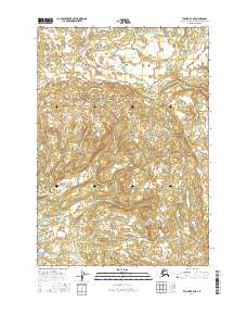
2016 Map of Tyonek B-4 NE
USGS Topo · Published 2016About this map
The Talachulitna River winds across the northern reaches of this remote Alaska landscape, marking a terrain defined by complex wetlands and shifting watercourses. Mapping data from the U.S. Geological Survey reveals a wilderness area within the Matanuska-Susitna region that remains largely untouched by modern road infrastructure or permanent settlements. The detailed contouring and hydrography provided by the National Hydrography Dataset highlight the intricate drainage patterns of the basin. This survey serves as a vital record of the interior waterways and public land divisions as they existed in the early twenty-first century, providing essential geographic context for those studying the uninhabited reaches of south-central Alaska.
Find a feature on this map
5 named features on this map. Tap any name to fly to it.
Don’t see what you’re looking for? This feature index may not catch every label — zoom into the map to look around manually.
Map Details
Editions of this 2016 Tyonek B-4 NE Map
This is the sole edition of this map. No revisions or reprints were ever made.
Other maps of this area

1949 · Tyonek
USGS Topo · 1:250,000

1951 · Tyonek
USGS Topo · 1:250,000

1954 · Tyonek C-4
USGS Topo · 1:63,360

1954 · Tyonek B-4
USGS Topo · 1:63,360

1954 · Tyonek C-3
USGS Topo · 1:63,360

1958 · Tyonek B-3
USGS Topo · 1:63,360

1958 · Tyonek
USGS Topo · 1:250,000

1965 · Tyonek
USGS Topo · 1:250,000
1993 · Tyonek C-3
USGS Topo · 1:63,360
2013 · Tyonek B-3 SW
USGS Topo · 1:25,000