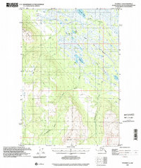
1993 Map of Tyonek C-3
USGS Topo · Published 2002About this map
The Iditarod Trail cuts across a vast landscape of wetlands and peaks in this 1993 edition, which combines 1950s topography with updated planimetric data from the early 1990s. The terrain is dominated by significant elevations like Beluga Mountain in the west and Mt Susitna to the south, while the lowlands are defined by a complex network of marshes and water bodies. Notable among these are Alexander Lake and the winding Alexander Creek, which provide a critical drain for the surrounding muskeg. Evidence of bush aviation and remote habitation appears in labels for Texas, scattered Cabins, and several landing strips used for backcountry access. The southern portion of the map is shaped by the Theodore River and Wolverine Creek, highlighting the diverse riparian systems that characterize this part of the Matanuska-Susitna Borough. This survey captures a specific moment of land-use documentation prior to the turn of the millennium.
Find a feature on this map
31 named features on this map. Tap any name to fly to it.
Don’t see what you’re looking for? This feature index may not catch every label — zoom into the map to look around manually.
Map Details
Editions of this 1993 Tyonek C-3 Map
This is the sole edition of this map. No revisions or reprints were ever made.
Other maps of this area

1949 · Tyonek
USGS Topo · 1:250,000

1951 · Tyonek
USGS Topo · 1:250,000

1954 · Tyonek D-2
USGS Topo · 1:63,360

1954 · Tyonek D-3
USGS Topo · 1:63,360

1954 · Tyonek C-4
USGS Topo · 1:63,360

1954 · Tyonek B-4
USGS Topo · 1:63,360

1954 · Tyonek D-4
USGS Topo · 1:63,360

1954 · Tyonek C-3
USGS Topo · 1:63,360

1958 · Tyonek C-2
USGS Topo · 1:63,360

1958 · Tyonek B-3
USGS Topo · 1:63,360