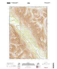
2017 Map of Tyonek B-8 SW
USGS Topo · Published 2017About this map
The Chiligun River valley cuts a deep southwest-to-northeast path through the heart of this 2017 survey, serving as the primary drainage for the surrounding highlands. Within the protected boundaries of Lake Clark National Park, the landscape is defined by massive elevational changes, as the terrain rises sharply from the riverbanks toward unnamed peaks. In the northeast corner, Max Lake sits perched at a high elevation, illustrating the high-altitude drainage patterns typical of the region. The map provides a precise look at the township and range divisions, including t14n r21w and t14n r20w, which overlay this nearly untouched wilderness area of the Kenai Peninsula.
Find a feature on this map
9 named features on this map. Tap any name to fly to it.
Don’t see what you’re looking for? This feature index may not catch every label — zoom into the map to look around manually.
Map Details
Editions of this 2017 Tyonek B-8 SW Map
This is the sole edition of this map. No revisions or reprints were ever made.
Other maps of this area

1949 · Tyonek
USGS Topo · 1:250,000

1951 · Tyonek
USGS Topo · 1:250,000

1951 · Lime Hills
USGS Topo · 1:250,000

1958 · Tyonek B-8
USGS Topo · 1:63,360

1958 · Tyonek
USGS Topo · 1:250,000

1958 · Tyonek A-8
USGS Topo · 1:63,360

1958 · Lime Hills B-1
USGS Topo · 1:63,360
1958 · Lime Hills A-1
USGS Topo · 1:63,360

1958 · Lime Hills
USGS Topo · 1:250,000

1965 · Tyonek
USGS Topo · 1:250,000