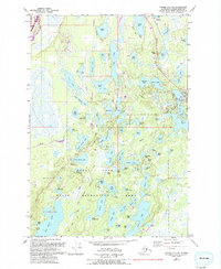
1979 Map of Tyonek C-1 NE
USGS Topo · Published 1993About this map
Willow anchors this portion of the Matanuska-Susitna Borough, appearing as a focal point for settlement and transportation along the George Parks Highway. The landscape is dominated by the complex hydrology of the Nancy Lake State Recreation Area, where dozens of named water bodies like Long Lake, Vera Lake, and Willow Lake create a fragmented mosaic of water and timberland. Revisions from 1988 aerial photography, shown in purple, highlight the development of local infrastructure including Michigan Street, Willow Lake Drive, and several private landing strips.
Find a feature on this map
87 named features on this map. Tap any name to fly to it.
Don’t see what you’re looking for? This feature index may not catch every label — zoom into the map to look around manually.
Map Details
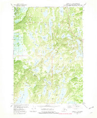
Editions of this 1979 Tyonek C-1 NE Map
2 editions found
Other maps of this area

1949 · Tyonek
USGS Topo · 1:250,000

1949 · Anchorage D-8
USGS Topo · 1:63,360

1950 · Anchorage C-8
USGS Topo · 1:63,360

1951 · Anchorage
USGS Topo · 1:250,000

1951 · Tyonek
USGS Topo · 1:250,000

1951 · Anchorage D-8
USGS Topo · 1:63,360

1952 · Anchorage C-8
USGS Topo · 1:63,360

1952 · Tyonek D-1
USGS Topo · 1:63,360

1952 · Tyonek C-1
USGS Topo · 1:63,360

1952 · Anchorage D-8
USGS Topo · 1:63,360