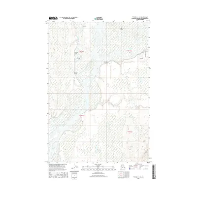
2016 Map of Tyonek C-1 NW
USGS Topo · Published 2016About this map
The Susitna River and Deshka River converge in this map, revealing a landscape defined by braided waterways and vast wetlands north of Tyonek. This 2016 survey documents several culturally significant sites along the river corridors, including Niqaghelelt, Sdak'dal'iy, and Tanltun Tesha. The intricate network of the Delta Islands and secondary water features like Kroto Slough illustrate the dynamic alluvial environment of the Matanuska-Susitna Borough. Near the eastern edge, the infrastructure around Deshka Landing Road and Deshka Loop represents the primary point of access for this riverine region. The placement of traditional sites such as K'chan Uq'e Tel'ihi and Ggis Uq'e Tel'ihi highlights the enduring indigenous geography of the Susitna basin in the early 21st century.
Find a feature on this map
18 named features on this map. Tap any name to fly to it.
Don’t see what you’re looking for? This feature index may not catch every label — zoom into the map to look around manually.
Map Details
Editions of this 2016 Tyonek C-1 NW Map
This is the sole edition of this map. No revisions or reprints were ever made.
Other maps of this area

1949 · Tyonek
USGS Topo · 1:250,000

1951 · Tyonek
USGS Topo · 1:250,000

1952 · Tyonek D-1
USGS Topo · 1:63,360

1952 · Tyonek C-1
USGS Topo · 1:63,360

1954 · Tyonek D-2
USGS Topo · 1:63,360

1954 · Tyonek D-1
USGS Topo · 1:63,360

1958 · Tyonek C-2
USGS Topo · 1:63,360

1958 · Tyonek C-1
USGS Topo · 1:63,360

1958 · Tyonek
USGS Topo · 1:250,000

1965 · Tyonek
USGS Topo · 1:250,000