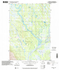
1993 Map of Tyonek C-2
USGS Topo · Published 2002About this map
The Iditarod Trail traverses this expansive riverine landscape, marking a vital historical corridor through the Matanuska-Susitna region. This survey, based on 1990s imagery, documents a complex network of waterways where the Yentna River and Alexander Creek converge amidst a dense collection of lakes and sloughs. The geography is defined by its seasonal utility, evidenced by the Winter Landing Strip and several isolated Cabins that dot the riverbanks, suggesting a landscape shaped by bush aviation and subsistence living.
Find a feature on this map
33 named features on this map. Tap any name to fly to it.
Don’t see what you’re looking for? This feature index may not catch every label — zoom into the map to look around manually.
Map Details
Editions of this 1993 Tyonek C-2 Map
This is the sole edition of this map. No revisions or reprints were ever made.
Other maps of this area

1949 · Tyonek
USGS Topo · 1:250,000

1951 · Tyonek
USGS Topo · 1:250,000

1952 · Tyonek D-1
USGS Topo · 1:63,360

1952 · Tyonek C-1
USGS Topo · 1:63,360

1954 · Tyonek D-2
USGS Topo · 1:63,360

1954 · Tyonek D-3
USGS Topo · 1:63,360

1954 · Tyonek D-1
USGS Topo · 1:63,360

1954 · Tyonek C-3
USGS Topo · 1:63,360

1958 · Tyonek C-2
USGS Topo · 1:63,360

1958 · Tyonek B-1
USGS Topo · 1:63,360