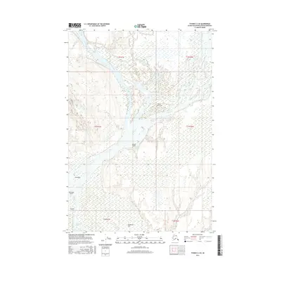
2016 Map of Tyonek C-2 SE
USGS Topo · Published 2016About this map
The Susitna River and Yentna River dominate this 2016 survey of the Matanuska-Susitna Borough, revealing a complex network of waterways and seasonal sloughs. The landscape is defined by its Dena'ina heritage, with traditional place names identifying key locations throughout the drainage. Significant sites such as Qalnigi Tel'iht and Yusdishlaq' reflect the enduring cultural footprint on the land, while the braided channels of Kroto Slough and the waters of Leech Lake illustrate the dynamic hydrology of the region. This modern topographic record preserves the native nomenclature of the Alaska interior, documenting landmarks like Beq'e Tach'itqeyi and the course of Fish Creek. The map provides a precise look at the township and range boundaries across T16N through T18N, anchoring these traditional spaces within the modern survey system.
Find a feature on this map
19 named features on this map. Tap any name to fly to it.
Don’t see what you’re looking for? This feature index may not catch every label — zoom into the map to look around manually.
Map Details
Editions of this 2016 Tyonek C-2 SE Map
This is the sole edition of this map. No revisions or reprints were ever made.
Other maps of this area

1949 · Tyonek
USGS Topo · 1:250,000

1951 · Tyonek
USGS Topo · 1:250,000

1952 · Tyonek C-1
USGS Topo · 1:63,360

1958 · Tyonek C-2
USGS Topo · 1:63,360

1958 · Tyonek B-1
USGS Topo · 1:63,360

1958 · Tyonek B-2
USGS Topo · 1:63,360

1958 · Tyonek C-1
USGS Topo · 1:63,360

1958 · Tyonek
USGS Topo · 1:250,000

1965 · Tyonek
USGS Topo · 1:250,000
1993 · Tyonek C-1
USGS Topo · 1:63,360