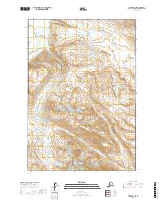
2017 Map of Tyonek C-6 NE
USGS Topo · Published 2017About this map
Trimble River flows through this high-altitude landscape in the Matanuska-Susitna Borough, defining the western drainage patterns of a region dominated by glacial terrain and steep contour gradients. In the northeast, the topographic layout highlights Hayes River Pass, a significant geographical corridor situated near Entrance Point. The map provides a detailed look at the hydrology of the area, including the upper reaches of Coal Cr. This 2017 survey reflects the remote wilderness of south-central Alaska, where the Public Land Survey System grids of t19n r15w and t18n r15w meet. The absence of roads or permanent settlements emphasizes the role of these natural landmarks as primary navigational references for bush pilots and backcountry travelers.
Find a feature on this map
8 named features on this map. Tap any name to fly to it.
Don’t see what you’re looking for? This feature index may not catch every label — zoom into the map to look around manually.
Map Details
Editions of this 2017 Tyonek C-6 NE Map
This is the sole edition of this map. No revisions or reprints were ever made.
Other maps of this area

1949 · Tyonek
USGS Topo · 1:250,000

1951 · Tyonek
USGS Topo · 1:250,000

1954 · Tyonek C-5
USGS Topo · 1:63,360

1954 · Tyonek D-5
USGS Topo · 1:63,360

1958 · Tyonek C-6
USGS Topo · 1:63,360

1958 · Tyonek D-6
USGS Topo · 1:63,360

1958 · Tyonek
USGS Topo · 1:250,000

1965 · Tyonek
USGS Topo · 1:250,000
2017 · Tyonek D-6 SE
USGS Topo · 1:25,000
2017 · Tyonek C-6 SE
USGS Topo · 1:25,000