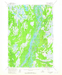
1954 Map of Tyonek D-1
USGS Topo · Published 1965About this map
The Susitna River dominates this mid-century landscape, carving a wide, braided path through the Matanuska-Susitna valley floor. To its east, the Alaska Railroad serves as the primary corridor for human activity, connecting small settlements like Caswell and Kashwitna as it parallels the river's course. The map reveals a transition from the complex waterways of the Delta Islands to the upland terrain of the Kashwitna Knobs. Transportation is largely dictated by the era's infrastructure, featuring the Willow Station Landing Strip and a network of Tractor Trails that snake through the dense wetlands and woods. This survey documents the area shortly after the 1950s, showing early development around Willow and Willow Lake, where Deception Creek meets the more substantial Willow Creek. The presence of several isolated Cabins suggests a period of remote homesteading and seasonal use along the tributaries.
Find a feature on this map
33 named features on this map. Tap any name to fly to it.
Don’t see what you’re looking for? This feature index may not catch every label — zoom into the map to look around manually.
Map Details
Editions of this 1954 Tyonek D-1 Map
3 editions found

Other maps of this area

1949 · Tyonek
USGS Topo · 1:250,000

1949 · Anchorage D-8
USGS Topo · 1:63,360

1950 · Talkeetna Mountains
USGS Topo · 1:250,000

1950 · Talkeetna
USGS Topo · 1:250,000

1950 · Anchorage C-8
USGS Topo · 1:63,360

1950 · Talkeetna Mountains A-6
USGS Topo · 1:63,360

1951 · Talkeetna
USGS Topo · 1:250,000

1951 · Anchorage
USGS Topo · 1:250,000

1951 · Tyonek
USGS Topo · 1:250,000

1951 · Anchorage D-8
USGS Topo · 1:63,360