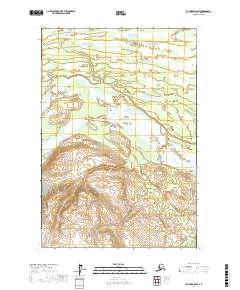
2017 Map of Tyonek D-5 NW
USGS Topo · Published 2017About this map
The Skwentna River dominates this Alaskan landscape, carving a wide braided path across the central valley. This 2017 survey reveals the intricate hydrography of the Matanuska-Susitna region, where the Hayes River joins the main flow amidst an expansive network of wetlands and seasonal floodplains. The terrain transitions from the low-lying river basins in the north to the rising elevation of the southern townships, defined by the t21n r14w and t21n r13w boundary markers. Smaller drainages like Shell Cr in the far north and Contact Cr at the southern edge provide specific points of reference for navigating this unpopulated wilderness area, illustrating the natural state of the upper Susitna drainage system before any modern development or infrastructure.
Find a feature on this map
8 named features on this map. Tap any name to fly to it.
Don’t see what you’re looking for? This feature index may not catch every label — zoom into the map to look around manually.
Map Details
Editions of this 2017 Tyonek D-5 NW Map
This is the sole edition of this map. No revisions or reprints were ever made.
Other maps of this area

1949 · Tyonek
USGS Topo · 1:250,000

1950 · Talkeetna
USGS Topo · 1:250,000

1951 · Talkeetna
USGS Topo · 1:250,000

1951 · Tyonek
USGS Topo · 1:250,000

1954 · Tyonek D-5
USGS Topo · 1:63,360

1954 · Talkeetna A-4
USGS Topo · 1:63,360

1958 · Tyonek D-6
USGS Topo · 1:63,360

1958 · Tyonek
USGS Topo · 1:250,000

1958 · Talkeetna
USGS Topo · 1:250,000

1965 · Tyonek
USGS Topo · 1:250,000