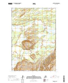
2017 Map of Tyonek D-6 NE
USGS Topo · Published 2017About this map
The Skwentna River and the Hayes River converge in this remote section of the Matanuska-Susitna Borough, defining a landscape of complex braided river channels and alluvial plains. This 2017 survey captures a wild drainage system where the glacial-fed waters shift across broad, marshy valleys, creating a network of sloughs and sandbars that are characteristic of the region's hydrography. Central to the topography is Porcupine Butte, a prominent elevation that rises sharply above the surrounding lowlands between the major watercourses.
Find a feature on this map
9 named features on this map. Tap any name to fly to it.
Don’t see what you’re looking for? This feature index may not catch every label — zoom into the map to look around manually.
Map Details
Editions of this 2017 Tyonek D-6 NE Map
This is the sole edition of this map. No revisions or reprints were ever made.
Other maps of this area

1949 · Tyonek
USGS Topo · 1:250,000

1950 · Talkeetna
USGS Topo · 1:250,000

1951 · Talkeetna
USGS Topo · 1:250,000

1951 · Tyonek
USGS Topo · 1:250,000

1954 · Tyonek D-5
USGS Topo · 1:63,360

1954 · Talkeetna A-4
USGS Topo · 1:63,360

1958 · Tyonek D-6
USGS Topo · 1:63,360

1958 · Talkeetna A-5
USGS Topo · 1:63,360

1958 · Tyonek
USGS Topo · 1:250,000

1958 · Talkeetna
USGS Topo · 1:250,000