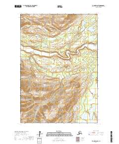
2017 Map of Tyonek D-6 NW
USGS Topo · Published 2017About this map
The Skwentna River winds through this section of the Matanuska-Susitna Borough, defining a landscape shaped by glacial runoff and complex drainage patterns. This 2017 topographic study reveals a wilderness environment where major watercourses like Old Man Cr and Red Cr feed into the river system. In the northeast, the presence of Red Lake and Finger Lake indicates a basin of smaller alpine or kettle lakes amidst the shifting elevations. To the south, Spring Cr marks the lower drainage as it moves through the southern townships. The map is primarily an examination of natural hydrography and terrain, showing no established road networks or settlements, emphasizing the remote character of this Alaskan interior region.
Find a feature on this map
10 named features on this map. Tap any name to fly to it.
Don’t see what you’re looking for? This feature index may not catch every label — zoom into the map to look around manually.
Map Details
Editions of this 2017 Tyonek D-6 NW Map
This is the sole edition of this map. No revisions or reprints were ever made.
Other maps of this area

1949 · Tyonek
USGS Topo · 1:250,000

1950 · Talkeetna
USGS Topo · 1:250,000

1951 · Talkeetna
USGS Topo · 1:250,000

1951 · Tyonek
USGS Topo · 1:250,000

1958 · Tyonek D-6
USGS Topo · 1:63,360

1958 · Talkeetna A-5
USGS Topo · 1:63,360

1958 · Tyonek
USGS Topo · 1:250,000

1958 · Talkeetna
USGS Topo · 1:250,000
1958 · Tyonek D-7
USGS Topo · 1:63,360

1965 · Tyonek
USGS Topo · 1:250,000