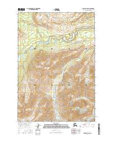
2016 Map of Tyonek D-7 NW
USGS Topo · Published 2016About this map
The Skwentna River winds through the northern reaches of this landscape, its wide channel and braided patterns indicating a dynamic glacial watercourse in the Matanuska-Susitna region. To the south, the terrain rises sharply toward the prominent Alger Peak, while the Chickak River flows northward through a narrow valley to join the larger Skwentna drainage. This 2016 survey captures the area's complex hydrology, including smaller tributaries like Portage Cr and Old Man Creek. The northern horizon is defined by the Long Lake Hills, where the relief begins to flatten. The map details the legal townships and ranges of the Alaska Public Land Survey System, specifically t22n r18w and t21n r18w, providing a precise framework for the undeveloped wilderness and its elevation contours.
Find a feature on this map
11 named features on this map. Tap any name to fly to it.
Don’t see what you’re looking for? This feature index may not catch every label — zoom into the map to look around manually.
Map Details
Editions of this 2016 Tyonek D-7 NW Map
This is the sole edition of this map. No revisions or reprints were ever made.
Other maps of this area

1949 · Tyonek
USGS Topo · 1:250,000

1950 · Talkeetna
USGS Topo · 1:250,000

1951 · Talkeetna
USGS Topo · 1:250,000

1951 · Tyonek
USGS Topo · 1:250,000

1958 · Talkeetna A-6
USGS Topo · 1:63,360

1958 · Talkeetna A-5
USGS Topo · 1:63,360

1958 · Tyonek D-8
USGS Topo · 1:63,360

1958 · Tyonek
USGS Topo · 1:250,000

1958 · Talkeetna
USGS Topo · 1:250,000
1958 · Tyonek D-7
USGS Topo · 1:63,360