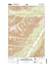
2016 Map of Tyonek D-8 NE
USGS Topo · Published 2016About this map
The Skwentna River flows through this high-latitude terrain within the Matanuska-Susitna Borough, defining the lower elevations of a landscape shaped by glacial water systems. This 2016 survey documents the intricate braided channel of the river as it moves through the eastern portion of the quadrangle, a characteristic feature of Alaska’s glacial-fed drainage basins. The area is dominated by significant relief, with the headwaters of Portage Creek and Portage Cr carving through the northern sections while Muddy Cr drains the southern slopes. The cartography provides a clear view of the Public Land Survey System boundaries, including the intersection of t22n r19w and t22n r18w. This map is particularly valuable for understanding the hydrologic patterns of the region before further environmental shifts, capturing the precise path of these waterways in the mid-2010s.
Find a feature on this map
8 named features on this map. Tap any name to fly to it.
Don’t see what you’re looking for? This feature index may not catch every label — zoom into the map to look around manually.
Map Details
Editions of this 2016 Tyonek D-8 NE Map
This is the sole edition of this map. No revisions or reprints were ever made.
Other maps of this area

1949 · Tyonek
USGS Topo · 1:250,000

1950 · Talkeetna
USGS Topo · 1:250,000

1951 · Talkeetna
USGS Topo · 1:250,000

1951 · Tyonek
USGS Topo · 1:250,000

1958 · Talkeetna A-6
USGS Topo · 1:63,360

1958 · Tyonek D-8
USGS Topo · 1:63,360

1958 · Tyonek
USGS Topo · 1:250,000

1958 · Talkeetna
USGS Topo · 1:250,000
1958 · Tyonek D-7
USGS Topo · 1:63,360

1965 · Tyonek
USGS Topo · 1:250,000