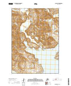
2019 Map of Ugashik A-2 SW
USGS Topo · Published 2019About this map
Port Wrangell and the surrounding coastal reaches of the Alaska Peninsula are documented in this 2019 survey, focusing on the interface between the peninsula's interior highlands and the Pacific coast. The northern portion of the map is defined by the course of the Agripina River, which cuts through the elevations of T35S R45W and T35S R46W. To the south, the terrain descends toward the shoreline of Chiginagak Bay, where the small landmark of Flat Island stands in the coastal waters. This representation shows the land as it exists within the Lake and Peninsula Borough, a region where the geography is shaped by water bodies and complex vertical relief, rather than human settlements or road networks. The map provides a precise look at the drainage patterns and topographical contours that define this portion of the peninsula.
Find a feature on this map
10 named features on this map. Tap any name to fly to it.
Don’t see what you’re looking for? This feature index may not catch every label — zoom into the map to look around manually.
Map Details
Editions of this 2019 Ugashik A-2 SW Map
This is the sole edition of this map. No revisions or reprints were ever made.
Other maps of this area

1943 · Ugashik
USGS Topo · 1:250,000

1948 · Ugashik
USGS Topo · 1:250,000

1949 · Ugashik
USGS Topo · 1:250,000

1951 · Sutwik Island
USGS Topo · 1:250,000

1951 · Ugashik A-2
USGS Topo · 1:63,360

1954 · Ugashik A-3
USGS Topo · 1:63,360

1954 · Sutwik Island D-3
USGS Topo · 1:63,360

1963 · Sutwik Island
USGS Topo · 1:250,000

1963 · Ugashik
USGS Topo · 1:250,000
1989 · Sutwik Island D-2
USGS Topo · 1:63,360