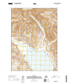
2019 Map of Ugashik A-3 SE
USGS Topo · Published 2019About this map
Chiginagak Bay dominates the southern reaches of this peninsula landscape, where the tides of the Pacific meet the dramatic relief of the Alaska Peninsula. The terrain is defined by extreme elevation changes, rising sharply from the shoreline into the high peaks of the Aleutian Range. This particular region, mapped in detail by the U.S. Geological Survey using modern imagery and elevation data, captures a remote wilderness devoid of roads or permanent settlements. Instead, the map reveals a complex network of drainage systems and ridges that dictate the natural movement across the land. The lack of human infrastructure highlights the raw geography of the Lake and Peninsula Borough, offering a precise record of the coastline and mountain contours as they stood in the early 21st century.
Find a feature on this map
7 named features on this map. Tap any name to fly to it.
Don’t see what you’re looking for? This feature index may not catch every label — zoom into the map to look around manually.
Map Details
Editions of this 2019 Ugashik A-3 SE Map
This is the sole edition of this map. No revisions or reprints were ever made.
Other maps of this area

1943 · Ugashik
USGS Topo · 1:250,000

1948 · Ugashik
USGS Topo · 1:250,000

1949 · Ugashik
USGS Topo · 1:250,000

1951 · Sutwik Island
USGS Topo · 1:250,000

1951 · Ugashik A-2
USGS Topo · 1:63,360

1954 · Ugashik A-3
USGS Topo · 1:63,360

1954 · Sutwik Island D-3
USGS Topo · 1:63,360

1963 · Sutwik Island
USGS Topo · 1:250,000

1963 · Ugashik
USGS Topo · 1:250,000
1989 · Sutwik Island D-2
USGS Topo · 1:63,360