
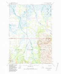
1963 Map of Ugashik A-6
USGS Topo · Published 1967About this map
Cinder River dominates this mid-century Alaskan landscape, its braided channels and wide floodplains cutting through a region defined by volcanic activity. The water bodies named on this sheet, including Pumice Creek and Lava Creek, reflect the geology of the Alaska Peninsula. Mapped by the Geological Survey via aerial photography from 1962, the document reveals a complex network of wetlands and swamps that surround the drainage of Old Creek. The terrain transitions from low-lying alluvial plains in the west to more prominent relief in the southeast near Ray Creek. This topographic study documents a wilderness before extensive development, where unsurveyed land lines pre-determined by the Bureau of Land Management remain the primary structural markers across the tundra and marsh.
Find a feature on this map
6 named features on this map. Tap any name to fly to it.
Don’t see what you’re looking for? This feature index may not catch every label — zoom into the map to look around manually.
Map Details
Editions of this 1963 Ugashik A-6 Map
2 editions found
Other maps of this area

1943 · Ugashik
USGS Topo · 1:250,000

1948 · Ugashik
USGS Topo · 1:250,000

1949 · Ugashik
USGS Topo · 1:250,000

1951 · Bristol Bay
USGS Topo · 1:250,000

1951 · Sutwik Island
USGS Topo · 1:250,000

1954 · Ugashik B-5
USGS Topo · 1:63,360

1963 · Ugashik B-6
USGS Topo · 1:63,360

1963 · Bristol Bay
USGS Topo · 1:250,000

1963 · Bristol Bay A-1
USGS Topo · 1:63,360

1963 · Sutwik Island
USGS Topo · 1:250,000