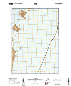
2019 Map of Ugashik B-1 SW
USGS Topo · Published 2019About this map
The Pacific Ocean dominates this coastal study, where the waters of the Shelikof Strait meet the rocky shoreline of the Alaska Peninsula. Situated within the Lake and Peninsula region, the landscape is defined by the prominent Cape Kayakliut and a series of offshore landforms, including the substantial Hartman Island and the smaller Titcliff Island. The survey documents the administrative boundary for the Kodiak Island Borough, which cuts across the maritime space in the eastern half of the quadrangle.
Find a feature on this map
11 named features on this map. Tap any name to fly to it.
Don’t see what you’re looking for? This feature index may not catch every label — zoom into the map to look around manually.
Map Details
Editions of this 2019 Ugashik B-1 SW Map
This is the sole edition of this map. No revisions or reprints were ever made.
Other maps of this area

1943 · Ugashik
USGS Topo · 1:250,000

1948 · Ugashik
USGS Topo · 1:250,000

1949 · Ugashik
USGS Topo · 1:250,000

1951 · Ugashik B-1
USGS Topo · 1:63,360

1951 · Ugashik A-2
USGS Topo · 1:63,360

1951 · Ugashik B-2
USGS Topo · 1:63,360

1963 · Ugashik
USGS Topo · 1:250,000
2019 · Ugashik A-2 NE
USGS Topo · 1:25,000
2019 · Ugashik B-1 NW
USGS Topo · 1:25,000
2019 · Ugashik B-1 SE
USGS Topo · 1:25,000