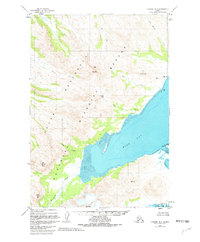
1951 Map of Ugashik B-2
USGS Topo · Published 1982About this map
Wide Bay dominates the coastline of this coastal wilderness, where early 1950s aerial photography captured a landscape defined by saltwater inlets and prominent summits. The shoreline transitions from the expansive Tidal Flat near the mouth of Kialagvik Creek to the deep waters of Imuya Bay in the south. Inland, the terrain is marked by significant elevations such as Deer Mountain, Mt Shannon, and Mt Alai, connected by high-altitude features like Sids Pass.
Find a feature on this map
24 named features on this map. Tap any name to fly to it.
Don’t see what you’re looking for? This feature index may not catch every label — zoom into the map to look around manually.
Map Details
Editions of this 1951 Ugashik B-2 Map
3 editions found
Other maps of this area

1943 · Ugashik
USGS Topo · 1:250,000

1948 · Ugashik
USGS Topo · 1:250,000

1949 · Ugashik
USGS Topo · 1:250,000

1951 · Ugashik B-1
USGS Topo · 1:63,360

1951 · Ugashik B-3
USGS Topo · 1:63,360

1951 · Ugashik C-1
USGS Topo · 1:63,360

1951 · Ugashik C-2
USGS Topo · 1:63,360

1951 · Ugashik C-3
USGS Topo · 1:63,360

1951 · Ugashik A-2
USGS Topo · 1:63,360

1951 · Ugashik B-2
USGS Topo · 1:63,360