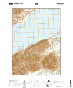
2019 Map of Ugashik B-2 SE
USGS Topo · Published 2019About this map
The Aleutian Range dominates the western portion of this 2019 survey, where steep peaks drop sharply toward the waters of Wide Bay. The coastline is defined by dramatic elevation changes and tidal features, including Titcliff Island situated along the eastern shore. The interior landscape is carved by seasonal drainages such as Preston Cr, which flows through high-altitude basins before reaching the coast. This map illustrates the intersection of mountainous terrain and the Pacific maritime environment, highlighting a region where natural topography dictates the lack of overland infrastructure and permanent settlement.
Find a feature on this map
10 named features on this map. Tap any name to fly to it.
Don’t see what you’re looking for? This feature index may not catch every label — zoom into the map to look around manually.
Map Details
Editions of this 2019 Ugashik B-2 SE Map
This is the sole edition of this map. No revisions or reprints were ever made.
Other maps of this area

1943 · Ugashik
USGS Topo · 1:250,000

1948 · Ugashik
USGS Topo · 1:250,000

1949 · Ugashik
USGS Topo · 1:250,000

1951 · Ugashik B-1
USGS Topo · 1:63,360

1951 · Ugashik A-2
USGS Topo · 1:63,360

1951 · Ugashik B-2
USGS Topo · 1:63,360

1963 · Ugashik
USGS Topo · 1:250,000
2019 · Ugashik A-2 NE
USGS Topo · 1:25,000
2019 · Ugashik B-2 SW
USGS Topo · 1:25,000
2019 · Ugashik B-1 NW
USGS Topo · 1:25,000