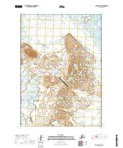
2019 Map of Ugashik B-6 NE
USGS Topo · Published 2019About this map
Ugashik Bay Airport serves as a critical waypoint in this expansive wetland landscape on the Alaska Peninsula. The terrain is characterized by a dense network of ponds and marshes, which underscores the geographical isolation and reliance on air travel for transportation in the region during the early twenty-first century. To the southeast, the King Salmon River winds through the coastal lowlands, a vital waterway in an area largely devoid of permanent roads. This 2019 survey documents the complex hydrology of the Lake and Peninsula Borough, showing how the natural drainage patterns and the small airfield are the primary features of an otherwise undeveloped wilderness. The map provides a clear record of the area's physical state, preserving the alignment of the river and the precise location of the airport facilities.
Find a feature on this map
6 named features on this map. Tap any name to fly to it.
Don’t see what you’re looking for? This feature index may not catch every label — zoom into the map to look around manually.
Map Details
Editions of this 2019 Ugashik B-6 NE Map
This is the sole edition of this map. No revisions or reprints were ever made.
Other maps of this area

1943 · Ugashik
USGS Topo · 1:250,000

1948 · Ugashik
USGS Topo · 1:250,000

1949 · Ugashik
USGS Topo · 1:250,000

1951 · Ugashik C-5
USGS Topo · 1:63,360

1951 · Ugashik C-6
USGS Topo · 1:63,360

1954 · Ugashik B-5
USGS Topo · 1:63,360

1963 · Ugashik B-6
USGS Topo · 1:63,360

1963 · Ugashik
USGS Topo · 1:250,000
2019 · Ugashik B-5 SW
USGS Topo · 1:25,000
2019 · Ugashik B-5 NW
USGS Topo · 1:25,000