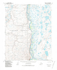
1955 Map of Umiat C-3
USGS Topo · Published 1986About this map
Colville River dominates the central landscape of this North Slope quadrangle, serving as a massive drainage artery fed by the Anaktuvuk River and Kogosukruk River. This 1950s survey captures a wilderness region designated as the National Petroleum Reserve in Alaska, characterized by an intricate network of lake-pocked tundra and shifting river channels. The only evidence of overland passage across these remote flats is the ephemeral Winter Trail, which winds through the southern terrain toward the prominence of Ulukshak Bluff. The map records a landscape shaped by seasonal freeze and thaw, where small watercourses like Ingaluat Creek and Kikak Creek carve through the sedimentary layers of the arctic coastal plain. This edition, with minor revisions through the mid-1980s, preserves the mid-century topography before modern resource extraction and climate shifts altered the hydrologic patterns of the region.
Find a feature on this map
9 named features on this map. Tap any name to fly to it.
Don’t see what you’re looking for? This feature index may not catch every label — zoom into the map to look around manually.
Map Details
Editions of this 1955 Umiat C-3 Map
2 editions found
Other maps of this area

1952 · Umiat
USGS Topo · 1:250,000

1955 · Umiat D-2
USGS Topo · 1:63,360

1955 · Umiat B-4
USGS Topo · 1:63,360

1955 · Umiat C-4
USGS Topo · 1:63,360

1955 · Umiat D-3
USGS Topo · 1:63,360
1955 · Umiat D-4
USGS Topo · 1:63,360

1955 · Umiat C-3
USGS Topo · 1:63,360

1955 · Umiat B-3
USGS Topo · 1:63,360

1956 · Umiat
USGS Topo · 1:250,000

1964 · Umiat
USGS Topo · 1:250,000