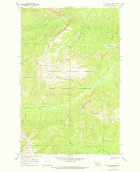
1970 Map of Una Mountain
USGS Topo · Published 1973About this map
The Bob Marshall Wilderness and Flathead National Forest intersect in this 1970 survey of Powell County's high country. Defined by extreme elevations and primitive access, the area is anchored by Una Mountain and the jagged Cardinal Peak to the south. The landscape is a complex drainage system where Gordon Creek and its many tributaries, including Gabe Creek and Cardinal Creek, carve through the mountainous terrain. Historical land use in this period is evidenced by a network of specialized routes such as the Bartlett Creek Pack Trail and the Holland Gordon Trail (Pack), illustrating how these remote peaks were managed and accessed before modern infrastructure. Geographic landmarks like the Nannie Basin and Bullet Nose Mountain provide specific reference points for those studying the physical history of the Montana Rockies.
Find a feature on this map
26 named features on this map. Tap any name to fly to it.
Don’t see what you’re looking for? This feature index may not catch every label — zoom into the map to look around manually.
Map Details
Editions of this 1970 Una Mountain Map
This is the sole edition of this map. No revisions or reprints were ever made.
Other maps of this area

1902 · Ovando
USGS Topo · 1:125,000

1905 · Ovando
USGS Topo · 1:125,000

1936 · Silvertip
USGS Topo · 1:96,000

1942 · Silvertip
USGS Topo · 1:125,000

1955 · Choteau
USGS Topo · 1:250,000

1957 · Choteau
USGS Topo · 1:250,000

1958 · Choteau
USGS Topo · 1:250,000

1962 · Choteau
USGS Topo · 1:250,000
1970 · Crimson Peak
USGS Topo · 1:24,000

1970 · Big Salmon Lake East
USGS Topo · 1:24,000