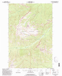
1994 Map of Una Mountain
USGS Topo · Published 1997About this map
Flathead National Forest and the Bob Marshall Wilderness dominate this high-altitude landscape in Powell County, Montana. The topography is defined by significant elevations like Una Mountain, Bullet Nose Mountain, and Cardinal Peak, which anchor a complex network of drainages and alpine basins. The map illustrates a primitive environment where hydrology dictates the movement through the terrain, with Gordon Creek and its many tributaries, such as Gabe Creek and Kid Creek, carving deep paths through the mountain ranges. Notable landforms like Nannie Basin provide specific locational data for researchers interested in the geomorphology of the Northern Rockies. This survey, revised in the early 1990s, documents the management boundaries and natural features of one of the nation's most protected wilderness areas, showing the land as it remained largely untouched by modern development.
Find a feature on this map
19 named features on this map. Tap any name to fly to it.
Don’t see what you’re looking for? This feature index may not catch every label — zoom into the map to look around manually.
Map Details
Editions of this 1994 Una Mountain Map
This is the sole edition of this map. No revisions or reprints were ever made.
Other maps of this area

1902 · Ovando
USGS Topo · 1:125,000

1905 · Ovando
USGS Topo · 1:125,000

1936 · Silvertip
USGS Topo · 1:96,000

1942 · Silvertip
USGS Topo · 1:125,000

1955 · Choteau
USGS Topo · 1:250,000

1957 · Choteau
USGS Topo · 1:250,000

1958 · Choteau
USGS Topo · 1:250,000

1962 · Choteau
USGS Topo · 1:250,000
1970 · Crimson Peak
USGS Topo · 1:24,000

1970 · Big Salmon Lake East
USGS Topo · 1:24,000