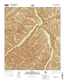
2015 Map of Unalakleet C-2 NW
USGS Topo · Published 2015About this map
The Nulato Hills dominate this portion of the Alaskan interior, forming a complex landscape of drainages and ridgelines. Winding through the eastern half of the map, the Old Woman River serves as the primary hydrological feature, cutting a path through the elevated terrain. This remote territory sits at a significant administrative juncture, where the Nome Census Area meets the Yukon-Koyukuk Census Area. The topographic detail reveals a region defined by its natural watercourses and the steady rise of the hills, showing the land as it remained in the early 21st century, largely untouched by permanent settlements or modern road infrastructure.
Find a feature on this map
7 named features on this map. Tap any name to fly to it.
Don’t see what you’re looking for? This feature index may not catch every label — zoom into the map to look around manually.
Map Details
Editions of this 2015 Unalakleet C-2 NW Map
This is the sole edition of this map. No revisions or reprints were ever made.
Other maps of this area

1950 · Unalakleet D-3
USGS Topo · 1:63,360

1951 · Unalakleet
USGS Topo · 1:250,000

1952 · Unalakleet C-2
USGS Topo · 1:63,360

1952 · Unalakleet D-2
USGS Topo · 1:63,360

1952 · Unalakleet C-3
USGS Topo · 1:63,360

1952 · Unalakleet
USGS Topo · 1:250,000

1964 · Unalakleet
USGS Topo · 1:250,000
2015 · Unalakleet C-2 NE
USGS Topo · 1:25,000
2015 · Unalakleet D-2 SW
USGS Topo · 1:25,000
2015 · Unalakleet C-2 SW
USGS Topo · 1:25,000