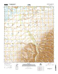
2015 Map of Unalakleet D-4 SE
USGS Topo · Published 2015About this map
The Iditarod Trail To Kaltag cuts across this northern landscape, marking a historic route of travel through the Alaska wilderness. The terrain is defined by the winding course of the Unalakleet River and its major tributary, the South River. These waterways, along with smaller seasonal drainages like Spring Camp Cr and Summer Camp Cr, dictate the movement across the tundra. The presence of the Eaton Station Road in the northeastern corner suggests a more modern layer of transit connecting to established river routes. Small water bodies including Ryan Lake and Grassy Lake dot the lowlands between the river bends, providing key landmarks for navigation. This survey illustrates the intricate relationship between traditional overland trails and the natural hydrological network that has guided travelers in the region for generations.
Find a feature on this map
17 named features on this map. Tap any name to fly to it.
Don’t see what you’re looking for? This feature index may not catch every label — zoom into the map to look around manually.
Map Details
Editions of this 2015 Unalakleet D-4 SE Map
This is the sole edition of this map. No revisions or reprints were ever made.
Other maps of this area

1950 · Unalakleet D-3
USGS Topo · 1:63,360

1950 · Unalakleet D-4
USGS Topo · 1:63,360

1951 · Unalakleet
USGS Topo · 1:250,000

1952 · Unalakleet C-3
USGS Topo · 1:63,360

1952 · Unalakleet C-4
USGS Topo · 1:63,360

1952 · Unalakleet
USGS Topo · 1:250,000

1964 · Unalakleet
USGS Topo · 1:250,000
2015 · Unalakleet C-3 NW
USGS Topo · 1:25,000
2015 · Unalakleet D-4 NE
USGS Topo · 1:25,000
2015 · Unalakleet D-3 NW
USGS Topo · 1:25,000