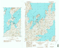
1990 Map of Unalaska C-2
USGS Topo · Published 1990About this map
Unalaska and its strategic maritime surroundings are detailed in this 1990 provisional study, compiled from 1983 aerial photography. The settlement pattern centers on the Iliuliuk River and Unalaska Lake, showing the close-knit development of the town with its City Hall, Cem, and the nearby Landing Strip. The map illustrates the complex coastline of the Aleutians, where Dutch Harbor and Iliuliuk Harbor provide sheltered waters protected by Amaknak Island and the heights of Mount Ballyhoo.
Find a feature on this map
39 named features on this map. Tap any name to fly to it.
Don’t see what you’re looking for? This feature index may not catch every label — zoom into the map to look around manually.
Map Details
Editions of this 1990 Unalaska C-2 Map
2 editions found
Other maps of this area

1951 · Unalaska
USGS Topo · 1:250,000
1989 · Unalaska B-1
USGS Topo · 1:63,360

1989 · Unalaska C-3
USGS Topo · 1:63,360
1989 · Unalaska D-1
USGS Topo · 1:63,360
1989 · Unalaska D-3
USGS Topo · 1:63,360
1989 · Unalaska D-2
USGS Topo · 1:63,360
1989 · Unalaska C-1
USGS Topo · 1:63,360

1989 · Unalaska B-2
USGS Topo · 1:63,360

1989 · Unalaska B-3
USGS Topo · 1:63,360

1990 · Unalaska C-2
USGS Topo · 1:63,360