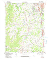
1982 Map of Union
USGS Topo · Published 1991About this map
Big Bone Lick State Park anchors the southwestern corner of this Boone County landscape, marking a site where paleontological history meets early Kentucky settlement. The map reveals a transition from the developing residential and commercial outskirts of Florence in the north to the more agrarian, creek-cut terrain of the south. Along the Southern railroad line, the settlement of Richwood is identified by its local church and interchanges, while the oddly named hamlet of Sugartit sits just north of the growing community of Union. Waterways like Gunpowder Creek and Mud Lick Creek define the topography, with family histories etched into the land at Baker Cem and Rice Cem. Evidence of mid-century infrastructure and recreation appears through the Kentucky Raceway and the New Haven Sch, illustrating a region balancing its rural roots with modern suburban expansion.
Find a feature on this map
59 named features on this map. Tap any name to fly to it.
Don’t see what you’re looking for? This feature index may not catch every label — zoom into the map to look around manually.
Map Details
Editions of this 1982 Union Map
2 editions found
Other maps of this area

1914 · West Cincinnati
USGS Topo · 1:62,500

1915 · Lawrenceburg
USGS Topo · 1:48,000

1928 · Lawrenceburg
USGS Topo · 1:62,500

1932 · Lawrenceburg
USGS Topo · 1:62,500

1943 · Rising Sun
USGS Topo · 1:24,000

1943 · Lawrenceburg
USGS Topo · 1:24,000

1943 · Patriot
USGS Topo · 1:24,000

1950 · Union
USGS Topo · 1:24,000

1950 · Independence
USGS Topo · 1:24,000

1950 · Verona
USGS Topo · 1:24,000