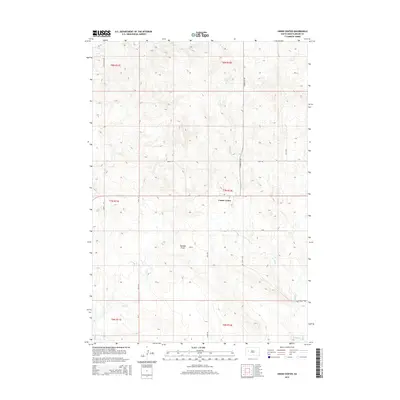
2015 Map of Union Center
USGS Topo · Published 2015About this map
Union Center serves as a central hub in this western South Dakota landscape, where the high plains are carved by seasonal drainage systems. The settlement is positioned at a key intersection of regional routes like Stoneville Rd, providing a look at the rural organization of Meade County in the mid-2010s. The terrain is defined by the headwaters of several creeks, including E Elm Cr and W Bull Cr, which snake through the varied elevations of the Maddox Draw. Local names like Tifft Rd and Chalk Butte Rd reflect the ranching and agricultural framework of the region. This survey highlights the sparse but vital infrastructure of the area, from isolated property access points like Omega Pl to the larger section-line roads that facilitate movement across the sprawling township and range grids.
Find a feature on this map
21 named features on this map. Tap any name to fly to it.
Don’t see what you’re looking for? This feature index may not catch every label — zoom into the map to look around manually.
Map Details
Editions of this 2015 Union Center Map
This is the sole edition of this map. No revisions or reprints were ever made.
Other maps of this area
1953 · Hereford NE
USGS Topo · 1:24,000
1953 · Rapid City
USGS Topo · 1:250,000
1954 · Haydraw
USGS Topo · 1:24,000
1954 · Boneita Springs
USGS Topo · 1:24,000
1957 · Rapid City
USGS Topo · 1:250,000
1959 · Fairpoint
USGS Topo · 1:24,000
1959 · Enning
USGS Topo · 1:24,000
1959 · Redowl
USGS Topo · 1:24,000
1959 · Stoneville
USGS Topo · 1:24,000
1959 · Union Center
USGS Topo · 1:24,000