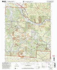
2002 Map of Union Furnace
USGS Topo · Published 2006About this map
The Hocking River carves a significant path through this section of the southeastern Ohio hill country, anchoring a landscape shaped by both industry and the preservation of natural lands. The presence of numerous Strip Mines and larger excavations reflects the region's long-standing reliance on resource extraction, particularly near settlements like Haydenville and Union Furnace. These industrial sites sit in close proximity to the wooded expanses of the Wayne National Forest, Zaleski State Forest, and the State Wildlife Area, illustrating the dual character of this terrain at the start of the 21st century. Genealogists will find a high density of rural burial grounds and places of worship, including Morris Chapel Cem, the Asbury Ch, and the remote Mt Zion Ch Cem situated along Zion Ridge. Smaller communities like Starr, Coonville, and Carbondale are interconnected by a network of winding roads like Whites Road and Dabney Road.
Find a feature on this map
46 named features on this map. Tap any name to fly to it.
Don’t see what you’re looking for? This feature index may not catch every label — zoom into the map to look around manually.
Map Details
Editions of this 2002 Union Furnace Map
This is the sole edition of this map. No revisions or reprints were ever made.
Other maps of this area

1903 · Athens
USGS Topo · 1:62,500

1904 · Zaleski
USGS Topo · 1:62,500

1905 · Athens
USGS Topo · 1:62,500

1907 · Zaleski
USGS Topo · 1:62,500

1907 · Logan
USGS Topo · 1:62,500

1909 · Logan
USGS Topo · 1:62,500

1911 · New Lexington
USGS Topo · 1:62,500

1947 · Columbus
USGS Topo · 1:250,000

1961 · Columbus
USGS Topo · 1:250,000

1961 · Nelsonville
USGS Topo · 1:24,000