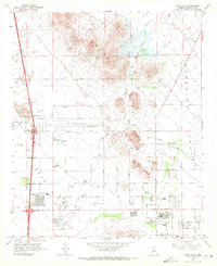
1964 Map of Union Hills
USGS Topo · Published 1972About this map
The Union Hills rise above a landscape defined by rapid mid-century expansion and infrastructure development on the northern edge of the Salt River Valley. During the 1960s, the area transitioned from open desert and grazing lands to an organized suburban grid, evidenced by the early footprints of the Village Meadows and Adobe settlements. The industrial and recreational life of the region is centered on landmarks such as the Deer Valley Airport and the Turf Paradise horse racing track, while the northern reaches of Deer Valley remain punctuated by smaller extractive operations like the Upton Mine and Turkey Track Mine. The hydrological character of the basin is managed through features like the Verde Canal and several water tanks, while prominent terrain features like Adobe Mountain and Buffalo Ridge provide natural boundaries to the emerging street network along Bell Road and Happy Valley Road.
Find a feature on this map
44 named features on this map. Tap any name to fly to it.
Don’t see what you’re looking for? This feature index may not catch every label — zoom into the map to look around manually.
Map Details
Editions of this 1964 Union Hills Map
4 editions found
Other maps of this area

1904 · Camelback
USGS Topo · 1:62,500

1906 · Camelsback
USGS Topo · 1:62,500

1930 · Cave Creek
USGS Topo · 1:125,000

1939 · Cave Creek
USGS Topo · 1:125,000

1954 · Phoenix
USGS Topo · 1:250,000

1954 · Mesa
USGS Topo · 1:250,000

1957 · Mesa
USGS Topo · 1:250,000

1957 · Phoenix
USGS Topo · 1:250,000

1957 · Hedgpeth Hills
USGS Topo · 1:24,000

1957 · Glendale
USGS Topo · 1:24,000