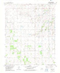
1982 Map of Union
USGS Topo · Published 1982About this map
Kingfisher County's agricultural and industrial landscape is documented in this 1982 survey, where the township of Union serves as a central point of interest. The area is defined by a dense network of sectional roads and extensive Oil Field activity that overlays the prairie terrain. Evidence of local community life is found at the Community Hall and multiple rural spiritual centers, including Oak Grove Ch and Nazarene Ch.
Find a feature on this map
19 named features on this map. Tap any name to fly to it.
Don’t see what you’re looking for? This feature index may not catch every label — zoom into the map to look around manually.
Map Details
Editions of this 1982 Union Map
This is the sole edition of this map. No revisions or reprints were ever made.
Other maps of this area

1892 · Kingfisher
USGS Topo · 1:125,000

1893 · Lovell
USGS Topo · 1:62,500

1893 · Hennessey
USGS Topo · 1:62,500

1895 · Kingfisher
USGS Topo · 1:125,000

1954 · Oklahoma City
USGS Topo · 1:250,000

1955 · Enid
USGS Topo · 1:250,000

1956 · Hennessey
USGS Topo · 1:62,500

1957 · Oklahoma City
USGS Topo · 1:250,000

1958 · Enid
USGS Topo · 1:250,000

1963 · Oklahoma City
USGS Topo · 1:250,000